
Amedikallu Trek
Amedikallu |
Nearest Towns: |
| Ujire |
Location info:India->Karnataka->Dharmasthala |
| Distances: |
| Camping Sites:The start of the trek was about 4 km from Vishnu Gokhale's house and Jeep to travel that distance. On the Jeep, few of us were sad about the latest developments that were taking place in Shishila. |
| Trek Length: 8 km.on way 6-8 hours of ascend and 4-6 hours of descend. |
Route Info: |
|
Bangalore -Nelamangala-Kunigal-Channarayapatana-Hassan-Sakaleshpura-Shiradi-Kokkada-Dharmasthala |
Best Time To Visit: |
Worst Time To Visit: |
Difficulty Level: |
| Moderate to very difficult depending on, There is only one source of water before steep 3-hour climb and no water at peak, which makes the path difficult to find and hidden rocks will hurt if stepped wrongly.which makes the whole trail slipperly and risky and infested with leeches.which makes it nearly impossible to errect tent and very difficultwalk on the trail.
|
Summary: |
|
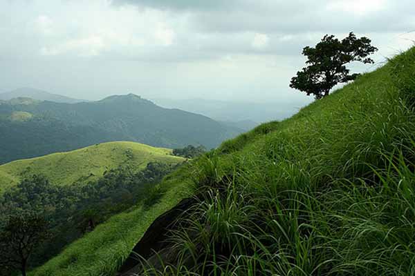
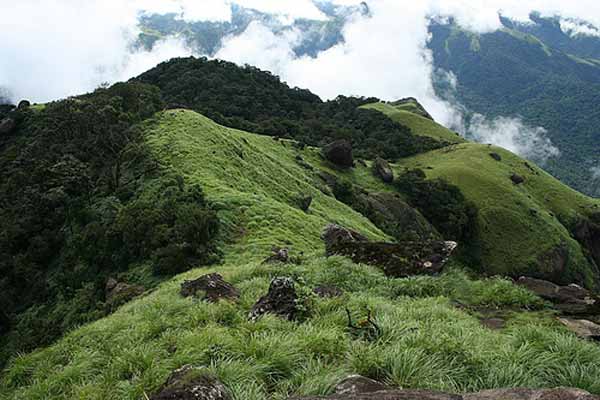
Amedikallu is a prominent peak in the Charmadi range of Western ghats. This peak is considered to be one of the toughest climb in Karnataka. The steep climb, grasslands and paucity of water make the trek arduous. There are two trekking routes to Amedikallu. The first one is from Neria estate which is relatively easier. But the estate owners supposedly donot let trekkers go through the estate these days. The second one is from Shishila which is tougher.Take a left turn on a narrow trail from Kandechhar and you are on your way! Again, without someone telling you, it is impossible to figure this narrow trail. The walk to Amedikal peak is one of continuous ascent and the first break you get from this monotony is only after about 2 hours of climb in the forest. Once you complete this stretch, you get a magnificient view of Amedikallu in front of you, and what awaits you next! The left side of the peak has three rocks neatly arranged to look like a stove. The main peak, at the center, looks like the outer shell of a turtle (ame = turtle, dikkel = tulu word for stove). The climb from this point to the peak is steep. But to get to a water source, we took a left turn just before the ascent. Ten minutes into the jungle, we came across a stream where we refreshed and had our packed lunch. |
Things To Look for: |
|
Alekhan Falls: This falls is at 3 km from Kottigehara town. Kottigehara is at 2 km trek from Amedikallu peak, but this route is difficult and steep. There is public transport available from Kottigehara to the falls on the highway and then descent of 15 minutes. Aanadka Waterfalls: To reach Aanadka Waterfalls, one has to reach Ujire first and travel towards Dhidupe which is flanked by Kudremukh National Park on one side and the Western Ghats on the other. The waterfall is located 4 km from Dhidupe. Donhole Waterfalls, on the Dharmasthala-Ujire Road, is located near Netravathi Bridge, about 10 km from Ujire. Donhole plummets from a height of 50 ft. The adjoining areas of the waterfalls are home to rare species of birds and flowers. Travel from Ujire to Cahrmadi Ghat. Just 3 k.m. before, at Kakkinge, take a right turn and travel along the Neriya road. Take a left turn at Aniyuru.From there, travel 3 k.m. to the left from, near the Gandibagilu Church, to reach the waterfall. As the Waterfall is situated inside private property, prior permission is necessary to access it. Ethina Bhujja: This is another nearby peak which is a 4 hour trek. Minchkallu Peak: This can be combined with Amedikallu (first day). One can do Minchkallu on second day directly from Amedikallu. Udaya Parvatha: This looks like a double peak, 2 peaks side by side. It is reachable from Shishila village. |
Things To Be Aware Of: |
|
Carry sufficient water before starting the steep climb.It is advisable to go in small group of 8-10 people since there is limited place for campingin case of rain. |
References |
| http://aravindgj.blogspot.com/2007/11/charmadi-day-two-anadka-and-ermayee.html |
Important Phone Numbers : |
|
Gopu Gokhale,ph:08251269246 |
Permission: |
| None required. |
SELECT YOUR HOLIDAY DESTINATION
-
Aero Sports in Karnataka
-
Archaeology in Karnataka
-
Beaches in Karnataka
-
Bird Sanctuaries in Karnataka
-
Bouldering Spot in Karnataka
-
Camping in Karnataka
-
Cave Explorations in Karnataka
-
Culturals Place in Karnataka
-
Dams in Karnataka
-
Districts Of Karnataka
-
Fairs in Karnataka
-
Festivals in Karnataka
-
Go Karting in Karnataka
-
Hill Stations in Karnataka
-
Historical Places in Karnataka
-
Holiday Resorts in Karnataka
-
Islands in Karnataka
-
Landscape in Karnataka
-
Mountain Biking in Karnataka
-
National Parks in Karnataka
-
Orbit Network
-
Para Sailing in Karnataka
-
Pilgrims Destinations In Karnataka
-
River rafting in Karnataka
-
Rivers in Karnataka
-
Rock Climbing in Karnataka
-
Safari in Karnataka
-
Temples in Karnataka
-
Trekking in Karnataka
-
Water Sports in Karnataka
-
Waterfalls in Karnataka
-
Wildlife Sanctuaries in Karnataka


