
Gurupura River
Gurupura or Phalguni |
About: |
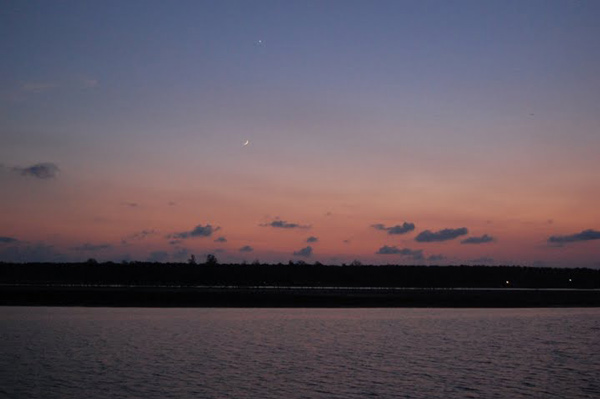
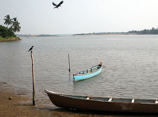
| Gurupura river flows through Gurupura, Mangalore, Tannirubhavi. It joins the Arabian sea near Tannir bhavi. is the chief port city of the Indian state of Karnataka. Bounded by the Arabian Sea and the Western Ghat mountain ranges, Mangalore is the administrative headquarters of the Dakshina Kannada (formerly South Canara) district in southwestern Karnataka. Mangalore derives its name from the local Hindu deity Mangaladevi. It developed as a port on the Arabian Sea - remaining, to this day, a major port of India. Lying on the backwaters of the Netravati and Gurupura rivers, Mangalore is often used as a staging point for sea traffic along the Malabar Coast. The city has a tropical climate and lies on the path of the Arabian Sea branch of the South-West monsoons. Mangalore's port handles 75% of India's coffee exports and the bulk of the nation's cashew exports. Mangalore lies on the backwaters of the Netravati and Gurupura rivers. These rivers effectively encircle the city, with the Netravti flowing at the south of the city, and the Gurupura flowing at the north of the city. The rivers form an estuary at the southern region of the city and subsequently flow into the Arabian sea.[51] The city is often used as a staging point for traffic along the Malabar Coast. The coastline of the city is dotted with several beaches, such as Mukka, Panambur, Tannirbavi, Suratkal, and Someshwara. Coconut trees, palm trees, and Ashoka trees comprise the primary vegetation of the city. |
Location info: |
| Address:Gurupura river flows through Gurupura, Mangalore, Tannirubhavi. It joins the Arabian sea near Tannir bhavi. |
| District:Mangalore |
| Nearest City:Mangalore |
| Best time to visit: The most pleasant months in Mangalore are from December to February, during which time the humidity and heat are at their lowest. During this period, temperatures during the day stay below 30 °C (86 °F) and drop to about 19 °C (66 °F) at night. |
Climate/Weather: |
| Mangalore has a tropical climate; summer and winter months experience similar temperate conditions, with average temperatures ranging from 27 °C (81 °F) to 34 °C (93 °F). Humidity is approximately 78% on average,[45] and peaks during May, June and July.[52] The maximum average humidity is 93% in July and average minimum humidity is 56% in January.[52] Under the Koppen climate classification, Manglore belongs to the Tropical/megathermal zone and is under the direct influence of the Arabian Sea branch of the South-West monsoon. It receives about 90% of its total annual rainfall within a period of about six months from May to October, while remaining extremely dry from December to March.[53] The annual precipitation in Mangalore is 4,242.5 millimetres (167 in).
The most pleasant months in Mangalore are from December to February, during which time the humidity and heat are at their lowest.[45] During this period, temperatures during the day stay below 30 °C (86 °F) and drop to about 19 °C (66 °F) at night. This season is soon followed by a hot summer, from March to May, when temperatures rise as high as 38 °C (100 °F). The summer gives way to the monsoon season, when the city experiences more precipitation than most urban centres in India, due to the Western Ghats.[55] Rainfall up to 4,000 millimetres (157 in) could be recorded during the period from June to September. The rains subside in September, with the occasional rainfall in October. |
History: |
| Mangalore was ruled by several major powers, including the Kadambas, Vijayanagar dynasty, Chalukyas, Rashtrakutas, Hoysalas, and the Portuguese. The city was a source of contention between the British and the Mysore rulers, Hyder Ali and Tippu Sultan. Eventually annexed by the British in 1799, Mangalore remained part of the Madras Presidency until India's independence in 1947. The city was unified with the state of Mysore (now called Karnataka) in 1956. |
Interesting things to do: |
Interesting things to Visit: |
| * Dharmasthala * Kukke Subrahmanya * Aati Kalanja Festival * Sri Mangaladevi Temple * St. Aloysius College Chapel |
Mobile range info: |
How to reach? |
| Nearest Railway Station:Rail connectivity in Mangalore was established in 1907. Mangalore was also the starting point of India's longest rail route.[41] The city has two railway stations - Mangalore Central (at Hampankatta) and Mangalore Junction (at Kankanadi).[138] A metre gauge railway track, built through the Western Ghats, connects Mangalore with Hassan. The broad gauge track connecting Mangalore to Bangalore via Hassan was opened to freight traffic in May 2006 [139] and passenger traffic in December 2007.[140] Mangalore is also connected to Chennai through the Southern Railway and to Mumbai via the Konkan Railway. |
| Nearest Airport:Mangalore International Airport (IATA: IXE) is near Bajpe, and is located about 20 kilometres (12 mi) north-east of the city centre. It is the second airport in Karnataka to operate flights to international destinations. |
| Road Transport:Mangalore's city bus service is operated by private operators and provides access within city limits and beyond. Two distinct sets of routes for the buses exist - city routes are covered by city buses, while intercity routes are covered by service and express buses. Karnataka State Road Transport Corporation (KSRTC) operates long distance bus services from Mangalore to other parts of the state.[136] The other key players who run bus services from Mangalore are the Dakshina Kannada Bus Operators Association (DKBOA) and the Canara Bus Operators Association (CBOA).[137] These buses usually ply from the Mangalore Bus Station. White coloured taxis also traverse most of the city. Another mode for local transport is the autorickshaw. |
Nearest Visiting places: |
| The district offers a wide range of interesting places for both pilgrimage and pleasure tourists such as Dharmasthala, Subramanya, Kollur, Udupi, Karkala, Venoor and Moodabidri. |
Nearest Petrol Pump: |
| Mangalore |
Hotels/Lodge/Accommodation: |
| * Taj Manjarun Hotel- Old Port Road, Mangalore 575001 Phone: +91-824-2420420 Fax: +91-824-2420585 Email: manjarun.mangalore@tajhotels.com * Hotel Maurya Netravati Phone: +91-824-411192 * Vimlesh International Ganapathi Temple Road, Mangalore * Hotel Srinivas G.H.S Road , Mangalore * Hotel Navarathna Palace K.S.Road, Mangalore, * Hotel Surya Greens Compound, Balmatta Road Mangalore-575001 * Summer Sand Beach Hotel, Ullal |
Things to carry: |
Tips & Suggestions: |
Help Line/Phone Number: |
| Police Station:Mangalore |
| Nearest Hospital:Mangalore |
| Society/Community Phone Number |


Gurupura or Phalguni Nearest Attraction |
| St. Mary's Island |
| Located 58 km north of Mangalore, the St. Mary's Island beach is special for the unique formation of basalt rocks which have crystallized into columns and split into vertical hexagonal blocks. This group of islands is accessible by ferry from Malpe which is a major fishing harbor.....more |
| Kollur Temples |
| Kollur Mookambika Temple, an important seat of Shakti worship is located in very picturesque surroundings at the foot of the Western Ghats in Kundapur taluk of Udupi district. This sacred place is situated on the banks of river sauparnika and surrounded by thickly wooded hills and has a natural formation resembling the Sri Chakra. Kollur is one of the seven mukti places which were created by Parashurama.....more |
| Udupi Temples |
| Udupi, the Kokani city is the headquarters of the Udupi District, Karnataka State, India. When one hears the name "Udupi" either "Udupi Krishna" or "Udupi Masala Dosa" comes to the mind. Of course the famous, Krishna temple is located in this city. The temple is famous for a unique statue of Lord Krishna.....more |
| Kollur Forest |
| Kollur is a tiny hamlet situated 40km Kundapur Town, about 140 km away from Mangalore City in Karnataka state in Southern part of India. This village lies at the foot of the Western Ghats, and is famous for the Mookambika temple, a Hindu pilgrim center.....more |
| Mookambika Wildlife Sanctuary |
| Located in Udupi District, Karnataka, Mookambika Wildlife Sanctuary spans over 247 sq km and is thick with evergreen, semi-evergreen and moist deciduous forests of the Western Ghats, and small patches of teak plantations. It is contiguous with the Sharavathi Valley Wildlife Sanctuary.....more |
| Someshwara Wildlife Sanctuary |
| Located in the Western Ghats, Someshwara Wildlife Sanctuary in Udupi District of Karnataka. This 88 sq km sanctuary is consists of semi-evergreen and evergreen forests. Wildlife species include tiger, leopard, wild dog, jackal, gaur, wild pig, sambar deer, spotted deer, barking deer, lion tailed macaque, bonnet macaque and common langur.....more |
| Karkala |
| Karkala is a town and also the headquarters of Karkala Taluk in Udupi district of Karnataka, India, and is located about 300 km from Bangalore. It lies near the Western Ghats. The first name of this town was Pandya Nagari during the Jain regime but afterwards it was changed to Karikallu because of black stones.....more |
| Koosalli Falls |
| The fabulous picnic spot, Koosalli waterfalls is located near Koosalli village in Kundapura. A series of six falls, one above the other, in splendid surroundings makes it one of the best waterfalls in the state. The combined height of all six falls is about 380 ft....more |
| Kedaka River |
| The Kedaka River is a river flowing through Kundapur and Gungulli in western India. It joins with the Souparnika River, Varahi River, Chakra River, and Kubja River and merges into the Arabian Sea.....more |
| Pangala River |
| Pangala is a village situated in Udupi taluk of Udupi district, Karnataka. India's National Highway number 17 (NH-17) road connecting Mangalore (Kudla or Mangaluru) to Mumbai (Bombay) passes through this village.The village is on the north banks of Pangala river.....more |
| Souparnika River |
| Souparnika River is a river flowing through Kundapur and Gangolli in western India. It joins with the Varahi River, Kedaka River, Chakra River, and Kubja River and merges into the Arabian Sea.Sauparnika is a sacred river which emerges from a verdant mountain near Maravanthe in Udupi District of Karnataka.....more |
| Udyavara River |
| Udyavara is a village on the outskirts of the town of Udupi, Karnataka, India. It is located to south of Udupi, and to the north of the Udyavara river. Udyavara was formerly called Udayapura. It was the capital of the Alupas.....more |
| Kaup Beach |
| Kaup Beach is located 12 km south of Udupi. It is situated on the coastal belt. The Kaup beach is one of the most beautiful beaches. Its placement is perfect. The beach with the 100 ft high lighthouse on the rocks is a photographer's paradise.....more |
| Malpe Beach |
| About 6 kms from Udupi, in South Canara is Malpe, an ideal picnic spot with its virgin beach. The endless stretch of golden sand, graciously swaying palm trees, the clear blue sky and the gurgle of the sea all set a perfect mood for an unforgettable holiday here....more |
| Trasi Beach |
|
Trasi is a beautiful place on the west coast of India, 100 km from Mangalore, 900 km from Mumbai and 12 km north from Kundapur.Here you can see a unique scene where a National highway separates the Arabian sea from the Sauparnika river.....more |
| Panna Island |
| ....more |
| Kudumari Falls |
| ....more |
| Seeta/ Seetha falls / Koodlu Theertha falls / Sita falls |
| ....more |
SELECT YOUR HOLIDAY DESTINATION
-
Aero Sports in Karnataka
-
Archaeology in Karnataka
-
Beaches in Karnataka
-
Bird Sanctuaries in Karnataka
-
Bouldering Spot in Karnataka
-
Camping in Karnataka
-
Cave Explorations in Karnataka
-
Culturals Place in Karnataka
-
Dams in Karnataka
-
Districts Of Karnataka
-
Fairs in Karnataka
-
Festivals in Karnataka
-
Go Karting in Karnataka
-
Hill Stations in Karnataka
-
Historical Places in Karnataka
-
Holiday Resorts in Karnataka
-
Islands in Karnataka
-
Landscape in Karnataka
-
Mountain Biking in Karnataka
-
National Parks in Karnataka
-
Orbit Network
-
Para Sailing in Karnataka
-
Pilgrims Destinations In Karnataka
-
River rafting in Karnataka
-
Rivers in Karnataka
-
Rock Climbing in Karnataka
-
Safari in Karnataka
-
Temples in Karnataka
-
Trekking in Karnataka
-
Water Sports in Karnataka
-
Waterfalls in Karnataka
-
Wildlife Sanctuaries in Karnataka


